No student devices needed. Know more
32 questions
Most ________ states gained independence after 1940.
South American
European
East Asian
African
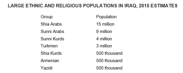
Based on the data in the table, which of the following is a possible impact of ethnic and religious diversity in Iraq?
Ethnicity and religion act as centripetal forces in the country by creating a common Iraqi identity among the population.
Ethnicity and religion facilitate democratization in the country by motivating participation in elections.
Ethnicity and religion promote economic development in the country by generating national pride in the country’s accomplishments.
Ethnicity and religion lead to devolutionary pressures in the country by politically dividing regions.
Ethnicity and religion increase cultural cohesion in the country by promoting shared political ideology.
When not all people within a state identify with the dominant sense of nationality, movements for separation of nation and territory may arise. All of the following are examples EXCEPT:
Quebecois, in Canada
the Basques, in Spain
the Kurds, in the Middle East
Jews, in Israel
Kurdistan is:
a sovereign nation bordered by Iraq & Turkey.
a stateless nation.
governed by Russia.
governed by Israel
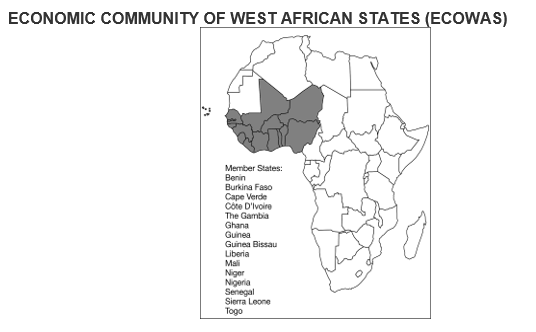
Which of the following is the correct organizational scale for the Economic Community of West African States (ECOWAS)?
global
supranational
national
state
local
The European state idea spread throughout the world through
relocation diffusion
economic development
League of Nations planning
contagious diffusion
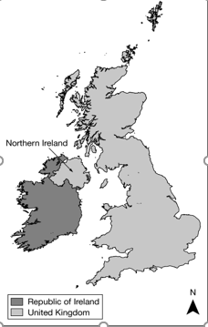
Based on the map, which of the following can be identified as a true statement about Northern Ireland?
It is unified with the rest of the island to form a sovereign nation-state.
It forms its own sovereign nation-state predominately made up of the Irish ethnic group.
It is a frontier that is not formally part of a state, but the United Kingdom claims the area.
It is physically separate from the rest of the United Kingdom, a multinational state.
It is a stateless nation, as the entire island of Ireland is under the control of the United Kingdom.
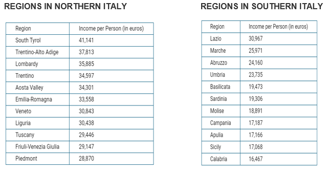
Which of the following possible political effects is implied by the data in the table?
The country’s high level of economic development acts as a centripetal force holding the state together.
The high level of economic difference between the regions in Italy acts as a devolutionary force.
The low level of economic difference between regions in Italy acts as a centripetal force holding the state together.
The low level of economic difference between regions in Italy promotes devolutionary movements in some parts of Italy.
The country’s low level of economic development promotes centrifugal forces tearing the state apart.
One of the most powerful impacts of colonialism was the construction of a global order characterized by great differences in
population
military and agricultural power.
economic and political power.
religious and economic power
The highly uneven distribution of economic and political power that developed from colonialism was due to the concentration of wealth brought back to
North America
Asia
Europe
Africa
Wallerstein’s views expressed in world systems theory hold that the global integrating force has been
capitalism.
the rise of the U.N.
socialism
colonial independence movements
Which of the following best explains why the region of Catalonia in Spain could be a viable country?
Catalonia is linguistically distinct compared to other regions in Spain.
Catalonia is well developed economically compared to other regions in Spain.
Catalonia's population is ethnically distinct compared to other regions in Spain.
Catalonia has a large population compared to other regions in Spain.
Catalonia has a major city, Barcelona, which has a notoriety comparable to that of the Spanish capital, Madrid.
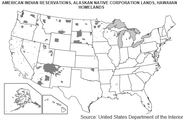
Which of the following terms identifies the type of regions shown in the dark gray-shaded areas on the map?
Functional regions
Urban regions
Physical regions
Vernacular region
Semiautonomous regions
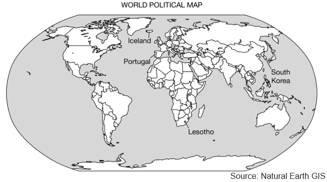
__________ is an example of a country which was never a classical colonial power.
Singapore
Portugal
Spain
Great Britain
The boundaries of independent African states were drawn at the Berlin Conference and were essentially drawn
without regard for ethnic divisions.
with great respect for ethnic groups.
along religious lines
along geographical lines
According to Hartshorne, forces that help build unity in a state are called:
centrifugal
devolutionary
religious diversity
centripetal
Nigeria is a state with a federal system of government. This fact is reflected in the adoption of _________ law in the states of the Muslim North.
British Common
Nigerian Federal
Sharia
local tribal
The movement of power from the central government to regional governments is referred to as ___
revolution
pluralism
supranationalism
devolution
Owing to their localized geography or their locations on islands or peninsulas, many small political entities such as those labeled on the political map of the world can be identified as
federal states
autonomous republics
multi-state nations
nation-states
colonial territories
Scotland and Wales are to the UK as ____________ are to Spain.
Basque and Catalonia
Kaliningrad and Lithuania
Honolulu and Guadalajara
South Korea and Cairo
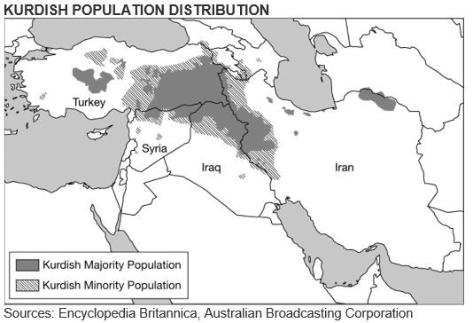
Based on the map above, which of the following best explains the implications of physical geography as the Kurds continue to struggle for an independent state in their ethnic homeland?
Israel, Turkey, and Russia have voiced their support for an independent Kurdistan in areas with a majority Kurdish population, showing potential validation for Kurdistan.
In September 2017 a public referendum was carried out that demonstrated that a majority of Kurds overwhelmingly support independence.
Most areas with a Kurdish majority population are landlocked and therefore dependent on good relationships with their neighbors in order to access trade and prosper economically.
Even in areas with a Kurdish minority population, Kurdish people have their own unique culture and identity separately from the states in which their nation is located.
Unstable oil prices have created economic problems both in parts of the region with a Kurdish majority population and in parts with a Kurdish minority, leaving the Kurdistan Regional Government weakened and struggling to pay off debt.
An official boundary between countries is a
line on the ground only
line shown only on maps
point of separation on and below the surface only.
vertical plane that cuts through the rocks below and air above.
Which is an example of an allocational boundary dispute?
dispute over the interpretation of boundary treaty terminology
dispute over boundaries not covered by a treaty (e.g. Yemen-Saudi Arabia)
dispute over the function of a boundary with regard to migration
dispute over rights to resources (e.g. oil, water) crossed by international boundaries
Geometric boundaries, totally unrelated to any aspects of the cultural or physical landscape, were made considerable use of by the European colonial powers in
Asia
South America
North America
Africa
In 1943, Sir Alfred Mackinder wrote about his heartland theory, expressing concerns over the potential of Stalin’s control of the countries of Eastern Europe. His views led to the development of the United States’ containment policy and to the establishment of
friendly relationships with China
the United Nations
N.A.T.O.
the Berlin Wall
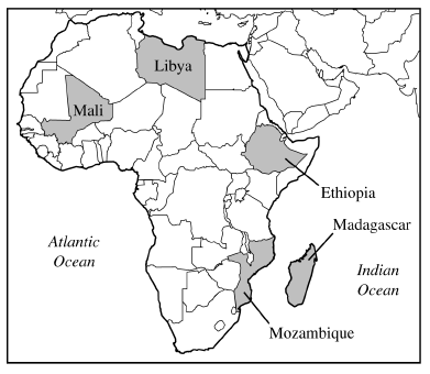
The map above shows the countries in Africa where private investors and foreign governments have leased farmland for large-scale commercial farming. Usually much of the food produced is bound for wealthier nations. This practice is an example of
decolonization
Pan-Africanism
neocolonialism
imperialism
irredentism
Technically supranationalism refers to efforts by ______ or more states to forge associations for common advantage and in pursuit of common goals.
2
3
4
5
Participation in the United Nations serves the useful purpose of committing states to do all of the following EXCEPT:
work together to prevent conflict
agree to world laws
respect international standards of behavior.
accept present political boundaries.
Which of the following best explains the political pattern shown in the table?
The devolution of Yugoslavia occurred primarily along national lines, resulting in countries with a defined ethnic majority.
The breakup of Yugoslavia was the result of a civil war in which ethnic groups fought for control of the capital of Belgrade in Serbia.
The Balkanization of Yugoslavia resulted in the formation of new ethnic nationalities divided by differences in religion and language.
The dissolution of Yugoslavia resulted in some ethnic groups being aligned with capitalist Western Europe and others being aligned with communist Eastern Europe.
The downfall of Yugoslavia was a case of ethnic differences becoming a centripetal force in the formation of a multistate nation.
The European Union’s future expansion into the Muslim realm by the inclusion of __________ is highly controversial and strongly opposed by Greece.
Saudi Arabia
Bosnia
Algeria
Turkey
According to Alexander Murphy, attachment to region and to the European Union is greater than attachment to the state in
Britain
Benelux
Switzerland
Yugoslavia.
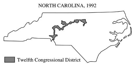
The shape of North Carolina’s Twelfth Congressional District, shown above, is most likely the result of
watershed boundaries
gerrymandering
county boundaries
decentralization
amalgamation
Explore all questions with a free account