
Louisiana Purchase
Assessment
•

Mr. Batista
•
History
•
11th - 12th Grade
•
130 plays
•
Medium
Improve your activity
Higher order questions
Match
•
Reorder
•
Categorization
.svg)
actions
Add similar questions
Add answer explanations
Translate quiz
Tag questions with standards
More options
10 questions
Show answers
1.
Multiple Choice
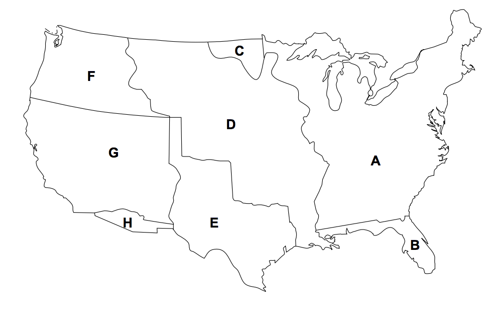
Which two areas of the map made up the United States in 1803 as a result of the Louisiana Purchase?
A and B
A and D
B and D
E and G
2.
Multiple Choice
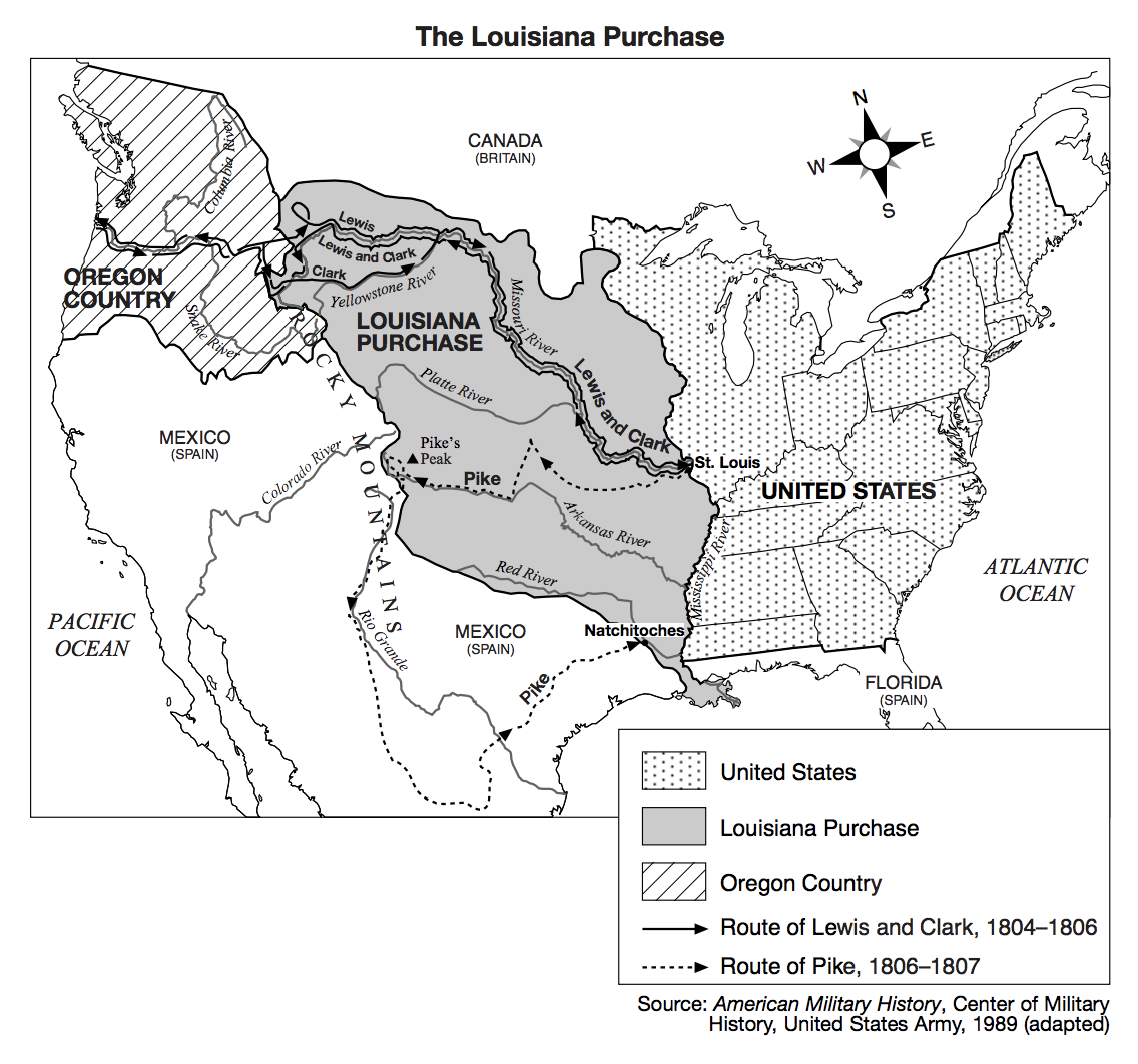
The United States purchase of the Louisiana Territory in 1803 was geographically important because it
Assured sole ownership of the Great Lakes.
Ended Spanish control of the Southwest.
Provided full access to the Mississippi River.
Allowed completion of the first railroad in California.
3.
Multiple Choice
Which group benefited the most from the United States acquisition of the port of New Orleans?
Farmers in the Ohio River valley.
Native American Indians in the Southwest.
Fur trappers in the Hudson River valley.
Gold miners in northern California.
4.
Multiple Choice
Which geographical consideration had the greatest influence on President Thomas Jefferson’s decision to purchase the Louisiana Territory in 1803?
Large gold reserves were located in the territory.
The size of the territory would create a barrier to French influence.
The Rocky Mountain region was an outlet for future population growth.
Full control of the port of New Orleans on the Mississippi River would be established.
5.
Multiple Choice
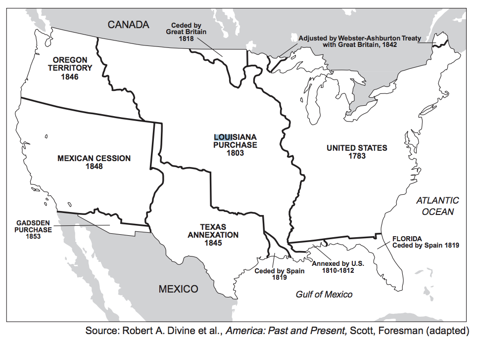
1803 — Louisiana Purchase Treaty established western boundary of United States.
1818 — Convention with Britain established northern boundary of Louisiana Territory.
1819 — Adams-Onís Treaty granted Florida to United States. 1842 — Webster-Ashburton Treaty established MaineCanada border.
1846 — Treaty of Oregon established northern boundary of Oregon Territory.
The time line shows that the major way the United States gained territory in the early 19th century was through
War
Diplomacy
Executive orders
Arbitration
6.
Multiple Choice
Which action of President Thomas Jefferson was in conflict with his belief in a strict interpretation of the Constitution?
Protesting the impressment of United States sailors.
Purchasing the Louisiana territory from France.
Pardoning violators of the Alien and Sedition Acts.
Using the United States Navy to subdue the Barbary pirates.

Explore this activity with a free account
Find a similar activity
Create activity tailored to your needs using

Louisiana Purchase
•
8th Grade
Lewis and Clark Expedition
•
6th - 8th Grade
Thomas Jefferson
•
5th - 8th Grade
Westward Expansion
•
8th Grade
Jefferson Era Review
•
8th Grade
Road to Revolution
•
7th Grade
Louisiana Purchase
•
5th - 8th Grade
Missouri Government Review
•
9th - 12th Grade